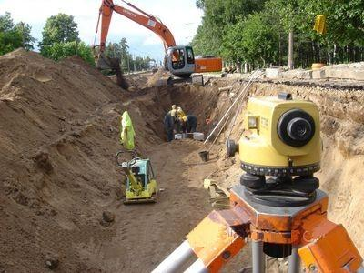
Tools and equipment for geodetic, topographic, and land surveying work
 Tools and equipment for geodetic, topographic, and land surveying work play a crucial role in measuring and analyzing land parcels, terrain, and geographic data. They provide accuracy, reliability, and efficiency when performing various tasks related to the study and utilization of land resources. Here are some of the key tools and equipment used in these fields:
1. Theodolites: Theodolites are used to measure horizontal and vertical angles, enabling the creation of maps and the determination of coordinates for points on the ground.
2. Levels: Levels are used to measure height differences between different points and to establish the topography for creating topographic maps.
3. GPS Receivers: GPS receivers are used to obtain precise geographic coordinates and create digital maps.
4. Total Stations: Total stations combine the functions of theodolites and levels, allowing for the simultaneous measurement of angles and distances.
5. Laser Distance Meters: Laser distance meters are used to measure distances with high accuracy.
6. Geodetic Stations: Geodetic stations combine various functions for measuring angles, distances, and heights, providing accurate geodetic data.
7. Satellite Imagery and Aerial Photography: Satellite imagery and aerial photography are used to create high-quality maps and analyze terrain.
8. GIS (Geographic Information Systems): GIS tools enable the processing, analysis, and visualization of geographic data for decision-making and planning.
9. Topographic Instruments: This includes maps, compasses, topographic tools, and other instruments for data collection in the field.
10. Excavators and Bulldozers: Heavy machinery such as excavators and bulldozers is used for earthworks and site preparation.
11. Seismographs and Ground-Penetrating Radars: These instruments are used to study underground structures and identify geological anomalies.
Choosing and using the right tools and equipment for geodetic, topographic, and land surveying work are essential for ensuring the accuracy and reliability of the obtained data and the results of studies in the fields of geodesy and geoinformation sciences. These tools are necessary for land management, geological research, construction project planning, and various applications related to land and terrain.


